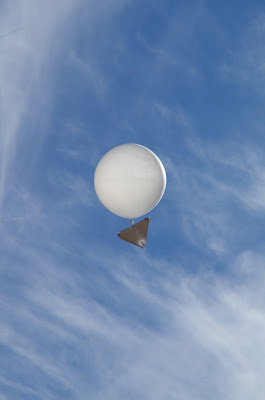
We visited the Longreach Bureau of Meteorology (BOM).
Twice a day, every day they launch a weather balloon to tell them information about the air currents (wind direction and speed).
The airport uses the information, which is why many BOM stations are located at airports.
To launch the weather balloon, they fill a balloon with helium. The balloon has a foil reflector attached. When it is released, it is tracked by computer using a giant metal detecting radar.
This is the balloon release station.
We also saw each of the other instruments used for weather monitoring.
Thermometer for measuring surface temperature
Thermometers for measuring soil temerature.
Both the ground and soil temperatures are used by farmers for knowing the best times to plant crop seeds, as well as for mine ventilation design.
This instrument measures the visibility of the air.
They regularly get readings of 60km+ for visibility at Longreach.
This instrument measures wind speed.
A rain gauge
The Duck Pond
This is used to measure evaporation over a 24hr period
This set of gadgets tracks the sun and measures the shielded and non-shielded radiation (UVA & UVB)
This box keeps the thermometers in the shade.
It measures minimum and maximum temperatures.
The forecast weather temperature shown on the news, in newspapers, smartphones & internet is the temperature in the shade (in this box). This is why if you measure the temperature in the sun, you end up with a higher temperature than what was forecast.
This is a computerised weather station.
This provides confirmation of all the other monitored conditions.


No comments:
Post a Comment